“What’s the Coast Guard Doing in Vietnam?” by Captain LeRoy Reinburg, Jr., U.S. Coast Guard–Retired

Share this:

This was the second question asked me by an Air Force colonel, when we were assigned together in Vietnam in the 1960s. Eyeing my cap device, his first question had been a polite, “What navy are you in?”

What’s the Coast Guard doing in Vietnam?” was a question I would hear many times during my tour. I served as commanding officer of the U.S. Coast Guard cutter Pontchartrain, a 255-foot, high-endurance cutter. As a unit of Coast Guard Squadron Three, the Pontchartrain, along with four other Coast Guard cutters, was part of Cruiser-Destroyer Group, U.S. Seventh Fleet. These cutters joined U.S. Naval vessels patrolling offshore on Operation Market Time, designed to deny the North Vietnamese the ability to resupply their army and the Viet Cong from the sea. An additional duty was to provide naval gunfire support to friendly forces with our 5-inch/38-caliber gun. Two of the more frequent users of this service were the American Division at Chu Lai and the U.S. Naval Riverine Force at Song Ong Doc. The fact that the Coast Guard cutters were armed with this weapon allowed the Navy to reduce the number of destroyers on the gun line and use their greater capability elsewhere in the Seventh Fleet.

Photo of U.S. Coast Guard cutter PONTCHARTRAIN taken in January 1970

USCGC PONTCHARTRAIN (WHEC-70) in January 1970, just prior to Southeast Asia deployment.

The first Coast Guard 82-foot patrol boats arrived in Vietnam in July 1965. They became part of the newly formed Navy Coastal Surveillance Force (CTF-115, Market Time). Their numbers ultimately increased to 29, as their effectiveness in interdiction became apparent. U.S. Navy Swift Boats would later be added to CTF-115. In 1965, however, the Coast Guard had the only small patrol craft capable of operating close inshore and up the rivers.

Coast Guard Squadron Three, composed of five high-endurance cutters, reported to Commander, Seventh Fleet, for Market Time duty on 4 May 1967, and remained in the combat area until January 1972. On 15 August 1970, under the U.S. Vietnamization program, the last of the 82-foot cutters was turned over to the Vietnamese Navy, and Coast Guard Squadron One was disestablished.

Coast Guard Squadron Three 1967-1971Although the extent of Coast Guard Operations in Vietnam is now, and was then, largely unknown to the general public, Coast Guard high-endurance cutters and patrol boats engaged in coastal interdiction with the Navy. Coast Guard port security and explosive-loading detachments served with the Army, and Coast Guard helicopters flew combat rescue missions with the Air Force. Coast Guard buoy tenders provided and maintained aids to navigation in U.S. military ports, and Coast Guard marine safety personnel supported merchant vessel operations. The Coast Guard built, maintained, and operated a chain of electronic navigation stations in Vietnam and Thailand, which provided accurate and reliable all-weather navigation data in support of U.S. air and surface operations. The accomplishment of these tasks involved a large portion of the Coast Guard’s ships and approximately 45,000 personnel.

Photo of litter on the deck of USCGC Pontchartrain after an all-night firing mission in 1970

Photo of U.S. Coast Guard cutter PONTCHARTRAIN off the coast of Vietnam, 1970, taken by LeRoy Reinburg, Jr.

The Coast Guard is justifiably proud of its military heritage. It has participated in every armed conflict in our nation’s history. The Coast Guard was established as an armed service by legislation enacted in 1915, although its forerunner, the Revenue Marine and Revenue Cutter Service, had held comparable status since 1799. Title 14 of the United States Code is the basic authority for this military status. Section 1 provides that the Coast Guard will be at all times a military service and a branch of the armed forces, although a component of the Department of Transportation, except when operating in the Navy.* Section 2 of that title states that the Coast Guard “shall maintain a state of readiness to function as a specialized service in the Navy in time of war.” Section 3 describes the Navy-Coast Guard relationship and states that the Coast Guard will operate as a service within the Department of the Navy (much the same as the Marine Corps) during time of war or when the President directs. This transfer has occurred only twice, during World Wars I and II. Coast Guard forces have been operational control of the Navy in all U.S. armed conflicts since World War II, however, and continue to serve in Southwest Asia and the Adriatic even today.

So when asked, “What was the Coast Guard doing in Vietnam?”, the answer is simply that it was performing its military function mandated by law.

*On 25 February 2003, the Coast Guard became part of the Department of Homeland Security. However, the Coast Guard still upon the declaration of war or when the President directs operates as a service in the Department of the Navy. (See Wikipedia’s History of the United States Coast Guard for a concise summary of key events in the Coast Guard’s history.)

(Originally published in Officer Review, Vol. 39 No. 3, October 1999, The Military Order of the World Wars.)

Share this:
Posted in U.S. Coast Guard in Vietnam, USCGC PONTCHARTRAIN, Vietnam War | Tagged , , , | 10 Comments

“If You Don’t Shoot Him, I Will,” by Captain LeRoy Reinburg, Jr., U.S. Coast Guard–Retired

Share this:

In 1950, I was a U.S. Coast Guard Ensign attached to the USCGC CLOVER (WAGL-292), a buoy tender whose homeport was Kodiak, Alaska. I had been on the CLOVER since the previous July and had spent only three weeks in Kodiak. Our area of operations was from Kodiak, west to Attu (the furthest west of the Aleutian Islands), and north to the Chukchi Sea as far as Point Hope. This included the entire Alaska coastline in between these limits, including the Pribilof Islands, on which the Coast Guard operated a Loran-A station in addition to several shore lights, Nunivak, and St. Lawrence Island in the Bering Sea.

Photo of St. Paul Harbor, Kodiak, Alaska

St. Paul Harbor, Kodiak, Alaska. Photo by LeRoy Reinburg, Jr., taken from U.S. Coast Guard Cutter CLOVER, 1950

Our operations were intense and involved being underway most of the time to cover this vast area. There were very few ports in that area and most were small villages. The largest of these were Nome, population about 1,200 and Unalaska, with a population of 250. ­In the spring of 1950, the Commander, Ketchikan Sector, our operational commander, ordered us to take over the area of responsibility of one of the SE Alaska tenders, which had departed for three weeks of shipyard availability in Seattle. This was a welcome reprieve from the tedium of our area. We proceeded to the Coast Guard Base, Ketchikan, to onload buoys and other equipment for our new job.

Photo of the U.S. Coast Guard cutter CLOVER

U.S. Coast Guard Cutter CLOVER, December 19, 1953 (U.S. Coast Guard photo)

Ketchikan at that time was one of the larger cities in Alaska, with a population of almost 3,000, a veritable metropolis to us. We also received on board our new Commanding Officer, a tall, slender, redheaded mustang LT, who had years of aids to navigation experience. For those of you are not familiar with the term “mustang,” it refers to an officer who rose from enlisted status. Or in the jargon of the service he “came up through the hawsepipe, instead of over the gangway.” He brought a wealth of experience, both on the West Coast and in Alaska. We soon found out that in addition to his other talents, he was an avid hunter and fisherman who held a license as a hunting guide in Alaska. It was just before this that I had become interested in hunting.

On a previous trip we stopped at Amchitka Island, a former U.S. Army Air Force Fighter Base in the Aleutians in WWII. Our task was to carry a U.S. Navy Explosive Ordinance survey team, which was assessing the large amount of explosives left when the war ended and the U.S. abandoned the bases. In addition to explosives, we found a large corrugated iron shed with a massive pile of weapons, both U.S. and Japanese, together with seemingly unlimited amounts of small arms ammunition. The U.S. Army Security Detachment who guarded the Island seemed anxious for us to take what we wanted within reason. I thought this was a wonderful opportunity to obtain some recreational firearms for the ship, and with my Commanding Officer’s approval, we selected several rifles and a carbine, with ammunition. All of these arms we locked up in the ship’s armory under strict accountability, to be used by the ship’s company for supervised recreational hunting trips.

When the new CO found out about this cache and my interest in hunting, he looked for opportunities in our busy operations to fit in some hunting. This suited me just fine, and I volunteered to go along on his hunting forays. Shortly thereafter, we were working some buoys in Icy Strait, just west of Juneau. At the end of the day, we found a quiet, sheltered cove to anchor overnight. As Navigator, I was in my customary station on the bridge, as we came up on our anchorage bearings, when the CO called my attention to several brown bears grubbing in the marsh several hundred yards away. As our anchor chain rattled in the hawsepipe, the bears, startled, ran off. We had a few more hours of daylight, and the CO suggested we go ashore after dinner and reconnoiter.

What followed was one of the most unforgettable experiences of my life. As our boat grounded on the mudflat of the marsh, a large brown bear ambled out of the woods, looking for grubs in the marsh grass. The CO, putting his finger to his lips, motioned me closer to him. In a low whisper, he told me he would work his way slowly to the left and get on the bear’s flank about 100 yards from him, while I slowly approached the bear from the front. When I got close enough and had a clear shot, I should shoot him. We were approaching down wind, since the bear has a keen sense of smell, although his eyesight is minimal. The CO, with his carbine, would be a backup for me with my .30 caliber M-1. I had bought some hollow point 220-grain ammunition in Ketchikan to replace the normal 160-grain conventional service projectiles. This was because the heavier hollow point projectiles had more power against an animal the size of a brown bear.

Brown bear, Alaska

Brown bear on the Cook Inlet coast, Alaska (U.S. National Park Service photo)

I approached the bear head on as close as I dared. I didn’t want the bear to have enough room to charge me in case I wounded him. I couldn’t get a shot at his body, just his head, which was a pretty small target. The bear kept grubbing and slowly moved sideways toward the CO. Finally, the CO, becoming increasingly more uncomfortable as the bear moved closer to him, stood up and said in a loud voice, “Reinburg, if you don’t shoot this SOB, I will.” The bear turned his head toward the CO’s voice, giving me a clear shot at his shoulder. I immediately fired and dropped him to the ground with my first shot.

The CO and I approached the bear slowly, with rifles at the ready, in case the bear was stunned. The CO went right up to the bear and announced “He’s dead.” Then came the question of what to do next. It was getting dark, and not too much light remained to skin the bear. So, we rolled him over until we reached the water, and assisted by the boat’s crew, put a line around his leg, and pulled him back to the ship. Fortunately, he floated.

We called the ship, which rigged the buoy boom with a tensiometer and hoisted him to the buoy deck. The tensiometer indicated he weighed 1,200 pounds!

The CO and I set about skinning the bear, with the only tools we had, that is, pocket knives. We removed the skin, even skinning out the feet. However, it became too dark and too late, so we decided to wait until morning to do the fourth foot. We removed the foot from the rest of the carcass, and pushed it overboard. Then we both turned in.

In the morning, I skinned out the remaining foot, packed the untreated skin in rock salt, and placed it in a barrel to preserve it until we returned to Ketchikan and I could ship it to a taxidermist in Seattle to turn into a rug, with an open mouth and teeth. Later, I did ship the bearskin to Seattle, and after a few weeks, received a letter from the taxidermist, who stated that the fur on the fourth foot had “slipped” and he couldn’t save it. Did I want the rug with three feet? I wrote back telling him to cut off the other three feet, after all why get a bear rug with only three feet? Shortly thereafter, I received the rug, which was beautifully done, with a head, open mouth, and bared teeth. Not too long after this, I received orders to attend the U.S. Naval Postgraduate School, located on the grounds of the U.S. Naval Academy in Annapolis, MD. While I attended the PG School, I roomed in the Bachelor Officers’ Quarters at the Naval Academy. My bearskin rug was the object of admiration of everyone who visited me.

In retrospect, I thought my hunting experience was very interesting, but I wasn’t too eager to do any more. Over the years, I have told this story endless times, but finally got around to writing it down in this account in June 2010.

Bear statue on the grounds of the U.S. Coast Guard Academy in New London, CT. April 2012.

Statue of bear on the grounds of the U.S. Coast Guard Academy, New London, CT. Photo taken by Claire Reinburg, April 2012.

Photo of Kodiak, Alaska

Kodiak, Alaska. Photo by LeRoy Reinburg, Jr., taken from the U.S. Coast Guard Cutter CLOVER, 1950

Share this:
Posted in Alaska, U.S. Coast Guard in Alaska, USCGC CLOVER | Tagged , , , | 6 Comments

“Bermuda 1946,” by Captain LeRoy Reinburg, Jr., U.S. Coast Guard–Retired

Share this:

In July of 1946, World War II had been over since the previous August with the dropping of the 2nd Atomic Bomb in history on Nagasaki, Japan. Regardless of how you view those two bombings (that is, Hiroshima and Nagasaki), it brought a terribly destructive war to an end. The U.S. was assembling the largest military force in history for the invasion of Japan. Forces were being moved from the European Theater of Operations (ETO), to the Far East in preparation for what was thought to be the final and most destructive battle of WWII. The Joint Chiefs of Staff estimated that we would suffer as many as 750,000 casualties, with unknown, but perhaps even larger numbers of casualties among the enemy, since they would be defending their homeland. The free world gave a collective sigh of relief when Japan agreed to an unconditional surrender. In the years since, I have spoken to many veterans who were being transported fresh from the battlefields in Europe to the Western Pacific to participate in the invasion. I have yet to find one of these who did not say that the Atomic Bombs saved hundreds of thousands of lives on both sides. Rumors were flying around the Coast Guard Academy that if Japan were invaded, my Class of 1948 would be graduated early to participate in the war effort. Obviously this did not happen.

Photograph of the schooner Atlantic, taken in 1929 in Long Island Sound.

The Atlantic, a 185-foot schooner, under sail in Long Island Sound in 1929. Photo from Mystic Seaport Museum.

After the war, things gradually returned to normal. A large number of my class of about 175 resigned as soon as the war ended. Within a year, we had less than 100 left. Over the next two years, as the rush to get out of the service continued, we eventually graduated 62! But in 1946, activities such as the Bermuda Sailing Races were restarted. This annual event had been discontinued when hostilities commenced. Ocean-going sailing craft flocked to register for the races in 1946. The Coast Guard Academy, which had been given the 173-foot topsail schooner ATLANTIC by its owner, Mr. Lambert, was entered into the race. The ATLANTIC, which still held the record for crossing the Atlantic under sail, was the fastest sailing ship of its size in the world. When the race reinstitution was announced, for the first time a category of large, unlimited size sailing ships was included. The ATLANTIC was a natural for the competition. It had been undergoing a revamp of its entire top hamper and was being converted from a topsail schooner to a club-footed staysail-rigged schooner. The three wooden masts were being replaced by steel masts. The old hoop and grommet rig for hoisting the sails was replaced by the latest technology in ocean racing, metal tracks on the forward and after part of the masts. These tracks were designed to carry sliding fittings, which were attached to the hoist of the sails. It was truly a radical design, and one that was intended to increase the speed of the ship under sail. Every effort was made to complete the conversion in time for the race, which if I remember correctly, was scheduled to begin about the middle of July 1946. For some reason, I, a second-class cadet, was picked as a part of the crew of the ATLANTIC, along with, it seemed to me, most of the members of the football team. This cruise was designed to be a shakedown cruise for the new rig. One odd feature of the other members of the crew were a number of Coast Guard Auxiliarists, who were included as a reward for their volunteer service during the war. The Auxiliary had been started in about 1940 to allow volunteers to assist the regular Coast Guard, which always seemed to be understaffed. In theory, the idea of their inclusion was a good one, in practice, it turned out otherwise. These men were mostly middle aged, overweight, and largely incapable of the heavy physical activity required on a large sailing ship. I spoke to several of them, and they seemed to be surprised that they were expected to work; they assumed that this was a pleasure cruise.

The race was the slowest in the history of the Bermuda Races. We had light airs for days at a time, interspersed with light gusts of wind. It took us 8 days to go from Montauk Point, on the eastern tip of Long Island, to Bermuda, a distance of about 500 miles. All of us were relieved when we sighted St. David’s Head on the north coast of Bermuda. The ATLANTIC, it became obvious, did not carry enough potable water to handle a crew our size. We were on water hours the whole time. Showers could not be used. We were a smelly bunch when we anchored in Hamilton Harbor, just off the U.S. Naval Base. When liberty was granted, the first thing that everyone looked for was a shower, followed by girls, and real food, in that order.

Our stay in Bermuda was about five days of glorious beaches, girls, food, and sightseeing. Bermuda did not allow automobiles, so it was either walk or ride a horse-drawn carriage. We had a wonderful time. But when those five days ended, we pulled up our anchor and departed Hamilton Harbor, headed for “home.” We had a fine steady wind from the north, which was ideal for our trip. We were close hauled on the starboard tack, and the old girl was strutting her stuff. We logged 13 knots the first day; it looked like a short trip to New London.

Suddenly, the weather changed, the barometer started to fall rapidly, and the wind increased so that our lee scuppers were under water most of the time. It was time to shorten sail. The wind increased to thirty knots, the seas were making up. As the barometer continued to drop, the wind increased steadily. This was when we discovered that the new design had one flaw, the sails were drawing so strong that the tracks became jammed, and it was difficult to lower the sails! We finally wrestled down the fore and main staysails and the mizzen, which was a fore and aft sail, but we couldn’t budge the topmast staysails; the tracks were hopelessly jammed and eventually pulled away from the masts. As the wind increased, it became obvious that we were in for a storm. The winds went from gale force (45 knots) to gusts of 60 knots. When this happened, the sails that were still up began flapping furiously (luffing doesn’t begin to describe it). The captain told us that it appeared that we were in an early season hurricane! As the sails began to beat themselves to pieces, the seas became mountainous, and the winds reached a steady hurricane velocity. We were taking a beating. Abruptly after about 12 hours, the wind suddenly dropped to “up and down,” and the seas became confused. After about a half hour, the wind abruptly shifted 180 degrees and returned to hurricane velocity. We had gone through the eye of the hurricane.

The schooner Atlantic at the dock of the U.S. Coast Guard Academy showing condition of sails after a hurricane, 1946.

The schooner Atlantic as she appeared at the U.S. Coast Guard Academy dock after weathering a hurricane enroute from Bermuda to New London, CT, 1946.

About 12 hours later, the wind began to abate, and without any power we wallowed in the mountainous seas, with only one lonely headsail to help keep our head into the wind. Eventually, the clew of this sail pulled out of the deck bringing a heavy brass fitting with it. This slashed around like a knife and made tatters of the jib. In the teeth of the booming gale, a large merchant ship pulled up close to us and signaled (our radio went out when the winds tore away the antenna) “Do you need any assistance?” Our captain, an experienced sailor, signaled back, “We are unable to render you any assistance.” After all, we were the Coast Guard; we would never admit we needed assistance!

In the teeth of the storm, an elderly Auxiliarist appeared on deck with his glasses tied to his head, wearing a life jacket whose pockets were filled with apples and oranges. He was obviously very frightened. He didn’t seem to know that by now the storm was abating. He asked me how far we were from the nearest land. I guess he was ready to abandon ship. I said to him, “We aren’t too far.” He brightened perceptibly and said, “What direction and how far?” I pointed straight down and said, “About 1 to 2 miles.” The look on his face showed me he didn’t think that was too funny, but I do believe he thought if someone could joke about the situation, it must not be too bad.

After the storm had passed, we jury rigged pieces of sails, and after four days, we made Montauk Point. We had just enough fresh water for our steam engine to bring us into New London. We were greeted by cheering crowds. I don’t think anyone expected to see us again! Confidentially, many of us weren’t too sure we’d make it either.

(Originally published in Officer Review, Vol. 49 No. 5, December 2009, The Military Order of the World Wars.)

Share this:
Posted in U.S. Coast Guard Academy | Tagged , , , , | Leave a comment

“Coast Guard Seagoing Justice,” by Captain LeRoy Reinburg, Jr., U.S. Coast Guard–Retired

Share this:

In 1954, when I was a Lieutenant in the U.S. Coast Guard, I was assigned as Commanding Officer of the USCGC MAGNOLIA, a 189‑foot buoy tender and former U.S. Army net tender. The “MAGGIE,” as she was affectionately known by the crew, was stationed at the Coast Guard buoy depot on Yerba Buena Island, in the middle of San Francisco Bay. We were responsible for maintaining the floating aids to navigation and lighthouses in San Francisco Bay and the northern California seacoast to the Oregon state line. The ship had a heavy schedule, which required us to be absent from our home port for two weeks each month. Each member of the ship’s company was needed to carry out our responsibilities. Anyone who didn’t carry his load increased the load on other members of the crew. One of the crewmen, a fireman, was a constant disciplinary problem. He was constantly “wising off” at the Senior Petty Officers who were his supervisors. He was late coming back from liberty, he couldn’t or wouldn’t get up at reveille, and he was always late for quarters and drills. The list of his minor infractions seemed endless.

A photo of the U.S. Coast Guard buoy tender MAGNOLIA

The U. S. Coast Guard cutter MAGNOLIA.

One morning, as I arrived at the ship, I was met at the gangway by the Exec, a customary sign of respect on board military ships. On this occasion, he seemed agitated, and he told me that he was placing this fireman on report. As we discussed this, it became evident that this time the man had gone way over the line in his resentment of authority. The Exec had given him a direct order to do (or not to do) some task. Rather than obey the order, the fireman invited the Exec to “come out on the dock and settle this man to man!” This was such a serious breach of discipline that I thought it necessary to handle it quickly and severely.

I must explain that I was aware that my authority to administer summary punishment was greatly increased if the offense was committed by a person who was “attached to, and embarked upon a ship.” At this point, my lawyer friends always wince as I tell this story. My ship was tied up to the dock, so I ordered that it be gotten underway. We hove to about 3 miles south of the depot, roughly in the center of the south part of San Francisco Bay. I had not planned to get underway that day, I had planned to grant all hands early liberty since it was Christmas Eve, but this incident required immediate attention.

Map showing locations of Yerba Buena Island and Treasure Island in San Francisco Bay

USGS map of San Francisco Bay, CA, showing the locations of Yerba Buena Island and Treasure Island.

In accordance with the Uniform Code of Military Justice, Article 15, I convened a “mast.” The term for this procedure has its origins in sailing ship days, when the Captain of the ship brought the accused “before the mast” to hold a disciplinary hearing. I advised the fireman that he had a right to remain silent, and then we heard the Exec read the charge. There were numerous witnesses to the incident; it was obvious that the fireman was guilty, and I found him so. I awarded him as punishment, one week’s confinement on reduced rations at the U.S Marine Disciplinary Barracks at the U.S. Naval Station, Treasure Island. I advised him that if he considered the sentence unjust or not consistent with that awarded in other cases, he could appeal this sentence to the Commander, Twelfth Coast Guard District (our operational commander.)

That completed, we returned to our berth at Yerba Buena Depot. The Exec called the Marine Disciplinary Barracks; the Marine guard came, received the formal incarceration papers, and picked up the fireman, who was hand cuffed and taken away. On New Year’s Eve, he was returned to the ship, much chastened and docile. We never had any problem with him for the remainder of the time I was on the ship. I heard informally that he had been discussing his confinement with his shipmates. He told them that the Marines held reveille at 0430 and did not allow them to sit down– even when eating– all day long. They were given rigorous drills and exercises until 2000, when they were allowed to turn in after an exhausting day. There was no radio, no TV, no reading material, and no conversation allowed. He told his shipmates that he would never want to go through that again.

Over the next several years, this incident gradually faded from my memory. By this time I was a Lieutenant Commander assigned to Coast Guard Headquarters in Washington, D.C. One day at lunch hour, as I was going to the bank to deposit my paycheck, I heard a familiar voice behind me saying, “Captain Reinburg.” Commanding officers, regardless of rank, are addressed as Captain. I turned and saw the fireman, now in civilian clothes, coming toward me. I wondered briefly if he intended to assault me in front of the many people passing by.

Instead, he approached, smiling, held out his hand, and shook mine warmly. He told me how wonderful it was to see me; he had hoped that he might again meet me some day. He said he wanted to thank me. He had been on a very destructive course, and I really turned his life around. He said that he was in his last year at George Washington University Law School, and he owed his success to me and the disciplinary action I took.

I returned to the office feeling a sense of accomplishment that I cannot describe properly. I felt as though I had “rescued” a lost sheep, and I had a heady sense of pride, although at the time of the incident I wondered if I overreacted.

(Originally published in Officer Review, Vol. 48 No. 8, April 2009, The Military Order of the World Wars. Awarded the Vice Admiral George C. Dyer Award, First Place.)

Share this:
Posted in USCGC MAGNOLIA | Tagged , | 1 Comment

“My Trip to Havana, 1944,” by Captain LeRoy Reinburg, Jr., U.S. Coast Guard–Retired

Share this:

On June 6, 1944, the largest military invasion force in history landed on the beaches of Normandy, France, to break the hold of Nazi Germany on the European Continent. I remember this day very well. I was a third class cadet at the U.S. Coast Guard Academy in New London, Connecticut. The entire cadet corps was lined up in the quadrangle of Chase Hall, the cadet barracks. It was about 0630, and we were in the middle of doing calisthenics. We would normally have been rowing, but the fog on the Thames River was so thick, that it was feared that we might become disoriented and drift down stream. This had actually happened a month before, and it had taken almost a day to locate all of the pulling boats.

Photo of U.S. Coast Guard Academy in New London, CT.

U.S. Coast Guard Academy in New London, CT. Photo taken by Claire Reinburg, April 2012.

While we were exercising, the Commissioned Officer of the Day, came out of Chase Hall, halted the exercises, and announced in a very solemn voice that the Allied invasion of Europe had begun. He dismissed us, and we all went back to our rooms to prepare for breakfast and talk about this historic event. Many of us wondered if this would mean that the war would end before we graduated and went out to the fleet. Whatever the effect this event would have on our lives, we knew that despite the fact that the submarine war at sea raged on off our coasts, we would still depart shortly for our summer practice cruise. Our itinerary had been posted on the bulletin board, and it included stops at Miami, Havana, St. Petersburg, and New Orleans.

Photo of Chase Hall, U.S. Coast Guard Academy, New London, CT

Chase Hall, U.S. Coast Guard Academy, New London, CT. Photo taken April 2012.

I think most of us were looking forward to seeing Havana, but as it turned out, the other ports were interesting as well. Our trip started with a troop train (we called it a cattle car) ride from New London, to the U.S. Marine Corps Base at Camp LeJeune, North Carolina. The trip down was miserable. The weather was miserably hot, and we were the last cars on a coal fired locomotive train. This was in the days before air conditioning. We had to open the windows because of the stifling heat, and the coal dust found its way into everything. We had about a four-hour layover in Union Station, Washington, D.C., but as I remember, it was from about 0100 to 0500, and we were not allowed to leave the train. I can’t imagine why we would have wanted to, anyway. The heat of the D.C. summer was almost unbearable.

The highlight of the trip was when we went slowly through Myrtle Beach about noon, and people lined the way waving to us, blowing kisses, and shouting words of encouragement. We spent three weeks at Camp LeJeune attending the Amphibious Warfare Training School, which involved loading combat-equipped Marines into LCVPs and LCMs (landing craft equipped with ramps on the bow) from a mockup of a transport ship, and debarking them on a sheltered beach. The beach landing, apparently, was only incidental to the Marines and our training; the debarking on cargo nets and entering the boats was the purpose of the enterprise. It was during one of these operations that I had exposure to a tragic training fatality. A Marine with full combat gear lost his grip on the cargo net and fell in between the boat and the mock transport. The water, as I recall, was quite deep, and before he could be rescued, he had drowned. I remember having tears running down my face. My boat was not directly involved, but it was a sad and sobering occurrence. Our training continued, making landings on the Atlantic Ocean beach through surf. I doubt that the purpose of our training was to make us proficient coxswains, but rather to make us aware of the problems associated with landing troops on unfriendly shores.

U.S. Coast Guard Cutter Cobb (WPG-181)

USCGC Cobb (WPG-181) was a United States Coast Guard cutter commissioned during World War II. The author, then-Cadet LeRoy Reinburg Jr.,
made a cadet cruise on the Cobb in the summer of 1944.

At the end of our training, we took buses to Charleston, South Carolina, and joined the U.S. Coast Guard Cutter Governor Cobb, a steam-driven coastal passenger ship that had been converted to an antisubmarine and convoy escort ship. It had a helicopter flight deck, although this was the very early days of the helicopter. It also had two 5”57 caliber guns, twenty millimeter antiaircraft machine guns, called Oerlikons, due to their Swedish manufacture, depth charge tracks, and K-guns. The ship was also equipped with Sonar and all of the latest electronics gear. Since we would be transiting German submarine–infested waters, we maintained strict darken ship. Each door leading to the weather decks had a darken ship switch, and as you exited these doors, they automatically shut off the interior lights. Walking the weather decks on a dark moonless night had its own hazards, and to help avoid knee-knocking and other hazards, luminous buttons were fastened to practically everything on the weather decks. We still had a lot of head and knee knocking. Of course, there were no open lights, including matches and cigarettes allowed on the weather decks.

U.S. Coast Guard Cutter Cobb, world's first helicopter carrier

A conversion of the 1906 coastal steamboat
SS Governor Cobb, USCGC Cobb in the hands of the
Coast Guard became the world’s first helicopter carrier. The first flight off the cutter occurred on June 29, 1944.

We reached Miami without incident, although the ship was very hot and uncomfortable. Many of us slept on the weather decks, and suffered the risk of being stepped on during the night. Miami was visible a long way off, because it was guarded by barrage balloons on the seaward side. Our visit was pleasant, although hectic. The local citizens had planned several social functions to which they had invited young ladies to be our dance partners and companions through the evening. Since we were tied up in downtown Miami, it was easy to get to the local sights.

After this, we headed for Havana, and, as usual, arrived off Morro Castle at the Havana Harbor Entrance, at 0800. After tying up to a cargo pier in the commercial port, liberty was granted to three of the four sections. The uniform for liberty was service dress white, and three of my classmates and I went ashore. We looked somewhat out of place on the dirty cargo pier, but somehow the word of our arrival had reached the cab fleet and we were able to flag down a cab. Two of my classmates had taken Spanish and told the cab driver that we wanted to go the Hotel Nacional, even pointing to it on a commanding height above the city. We were going there because the city had arranged a dinner dance for us that evening, and we wanted to see what it was like in advance.

LeRoy Reinburg, Jr., (second from left) with U.S. Coast Guard Academy classmates at Sloppy Joe's Bar in Havana, Cuba, 1944.

LeRoy Reinburg, Jr., (second from left) with U.S. Coast Guard Academy classmates at Sloppy Joe’s Bar in Havana, Cuba, 1944. The cadets were on a summer cruise aboard the U.S. Coast Guard Cutter Governor Cobb. From left to right, Mitton Neuman, LeRoy Reinburg, Jr., Bill Nielson, and Al Nordon. (Photo from Reinburg’s collection.)

We pulled up in front of a one story, nondescript building, and the cab driver said: “Hotel Nacional,” pointing to the building. We thought we may have made a mistake in identifying where we wanted to go, so one of us was elected to go inside to check it out. He came back saying it was a house of prostitution. After much bickering and browbeating, we finally made it to the real Hotel Nacional. The party wasn’t supposed to start for several hours, so we went back out to see some of the city. This time the cab driver took us to where we wanted to go, Sloppy Joe’s Bar, an internationally known watering place for visiting celebrities. The lesson we learned was if a cab picks up a sailor on the dock, the first thing he wants, in their view, is a prostitute.

The rest of the visit is somewhat of a blur. The party was wonderful. The young ladies were apparently from well-to-do families and had to travel with a duenna. Dating as we knew it in the States was entirely different, but we traveled in groups; some of us even got invitations to dinner with Cuban families. We traveled around the old city and had a delightful time on our own. I still have a photo of me and three of my classmates in Sloppy Joe’s. All in all it was a very pleasant and educational visit. Batista was the head of the Cuban Government, and it seemed a very happy, cosmopolitan city. Fidel Castro changed all of this in the 1950s. Now if what I read in the papers is true, everyone appears equally miserable.

Our port visit to St. Petersburg was very pleasant. I remembered it from my childhood. Here again, the citizens gave us a dinner dance, with local young ladies to socialize and dance with.

We lay off the east entrance to the Mississippi, awaiting first light to pick up a pilot for the 60 or so miles up the river to New Orleans. However, at about 0200, the sky and surrounding Gulf of Mexico was lit up by the fire from a burning oil tanker about five miles away that had been torpedoed by a German Submarine, so we immediately sought the shelter of the river, rather than being a sitting duck. We transited the river to New Orleans and arrived at a cargo pier at first light. The only incident I remember here was the accidental discharge of a forty-five-caliber pistol by the relieving officer of the deck inside the warehouse on the pier, which made a hole in the corrugated iron roof, and scared the hell out of everybody.

(Originally published in Officer Review, Vol. 49 No. 3, October 2009, The Military Order of the World Wars.)

Share this:
Posted in U. S. Coast in World War II, USCGC COBB | Tagged , , , , , | Leave a comment

“A Deep Problem,” by Captain LeRoy Reinburg, Jr., U.S. Coast Guard–Retired

Share this:

In February, 1970, the ship that I commanded, the Coast Guard Cutter PONTCHARTRAIN, departed from its home port of Long Beach, California, for a ten-month deployment to Vietnam to join four other High Endurance Cutters which composed Coast Guard Squadron THREE. There had been a flurry of activity prior to this, which included three weeks of refresher training at the U.S. Navy Fleet Training Group San Diego and efforts to bring on board a complete inventory of spare parts for all equipment.

Photo of U.S. Coast Guard cutter PONTCHARTRAIN taken in January 1970

USCGC PONTCHARTRAIN (WHEC-70) in January 1970, just prior to Southeast Asia deployment. From the author’s photos.

In addition, there were commissary supplies to bring on board, plus fuel and a wartime allowance of ammunition. All of these activities were time consuming and came amid the personal family arrangements everyone on board had to make to ensure their loved ones had what they needed for this long absence. My wife Marge had our six children to care for, and although she had endured my long absences when we were in Hawaii, this one was twice that long. I was apprehensive about what problems she might have to face alone. Personnel on board Coast Guard and Navy ships now have access to e-mail and ship-to-shore telephone, this was not so in those days. We weren’t completely out of touch, but communications with family, other than by mail, were difficult to arrange, except on an emergency basis.

We had two weeks between refresher training and our departure to arrange all of this, and these were hectic times, to say the least. In the middle of this “fire drill,” some one in the District Office decided to give us a new radar and a new fathometer. These were certainly worthwhile things to do to enhance our operational capability, but somehow, spare parts to keep these new pieces of equipment maintained didn’t show up prior to our departure. We were assured that they would be shipped air freight with the highest priority, and we would have them prior to our first combat patrol.

The air conditioning in the radar room failed while we were transiting the Verde Island Passage and the Sibuyan Sea (the route of the Spanish Galleons) at night with heavy ship traffic all around us. The electronics officer wanted permission to shut down the radar, which is very heat sensitive. I gave him a flat “NO!” We were in pilot waters on a dark, clear night, with many ships passing us and overtaking us. We would be unable to track any of them. We had to use the radar for the safety of the ship. At daybreak, the radar failed and we had no spare parts to fix it. The emergency was over, however, for now, and we arrived at Subic Bay that morning. When we arrived, the “priority air freight” of the radar parts had not materialized, nor had those for the fathometer. At this time we were also advised that our fathometer was so new, we were one of two ships to have it and that spare parts were not in the Navy inventory. What a great way to start our combat mission!

The time came to depart for our first combat patrol. I told the Squadron Commander (known irreverently as the Squad Dog, after his signal hoist), that the spare parts had not arrived for our radar, and this would seriously degrade our combat capability. He ruminated on this report for a few minutes, then said: “Well, Christopher Columbus didn’t have a radar.” This then was my answer, and we left the following morning. It wasn’t until well into our second three-week combat patrol off the coast of Vietnam that we received the radar parts, and we were back in business again.

CDR Reinburg on the bridge of the USCGC PONTCHARTRAIN off the coast of Vietnam in June 1970

Commanding Officer CDR Reinburg on the bridge of USCGC PONTCHARTRAIN off the coast of Vietnam, June 1970. From the author’s photos.

We completed our deployment of ten months without ever getting the spare parts for our fathometer, which, predictably failed after our first patrol. We were frequently operating in very shallow water for our gunfire missions, and not having a fathometer was not only irritating, but hampering to our operations. As we came into our first firing position, I asked the OOD what the depth of the water was. He replied that the fathometer was inoperative. I said: “I know that, but how deep is the water?” He told me that there wasn’t any way to determine it. Technology had come so far that he didn’t even know what a lead line was. I found to my astonishment, that the first lieutenant didn’t know either. What was even more unsettling, the chief boatswains mate, who had over twenty years service, had no idea of what I was talking about!

Title page of Knight's Modern Seamanship, 10th edition.

Title page of author’s copy of Modern Seamanship, by Austin M. Knight, 10th edition.

I broke out my copy of Knight’s Modern Seamanship, a standard text that I had used when I was a cadet twenty years before. I showed all of them what a leadline was, how to mark it, how to arm it (you put soap in a recess in the bottom of the lead weight, and this allows you to tell what the bottom is composed of), how to swing it, and the fact that “chains,” a small platform rigged outside the “eyes of the ship,” that is, the top deck on the bow of the ship, were needed to allow the leadsman to swing the lead clear of the ship.

After much embarrassment on the part of the first lieutenant and the chief boatswains mate, somewhere in the dark reaches of the first lieutenant’s locker (a storage location for material used by the deck force), a lead was found. I guess no one knew what it was so they were afraid to throw it away. Leadlines had been used to determine the depth of the water since probably Columbus’s time or before, but we had become so accustomed to electronic fathometers that we had forgotten all about them. After this, as we approached shoal waters, the OOD gave the order: “Man the chains!” and miraculously, we had a way to find out how deep the water was!

A lead line(Originally published in Officer Review, Vol. 50 No. 4, November 2010, The Military Order of the World Wars.)

Share this:
Posted in U.S. Coast Guard in Vietnam, USCGC PONTCHARTRAIN | Tagged , , | 2 Comments

“Rongelap Atoll, 1963,” by Captain LeRoy Reinburg, Jr., U.S. Coast Guard– Retired

Share this:

The first thermonuclear device, called “Mike,” was detonated on a small, unnamed island in the northern part of Eniwetok Atoll, Marshall Islands, in 1952. The blast destroyed the islet and left a large underwater crater, which in 1963 was marked on the southern side by two first class cans. This was followed almost two years later by a new test program called “Operation Castle” at Bikini Atoll, the site of the first atomic bomb tests in 1946 following World War II. The first shot in this planned series was “Bravo,” a surface shot with a yield of fifteen megatons, very much more powerful than “Mike.”

The detonation occurred on March 1, 1954, at 0645, but that morning when the great volume of radioactive particles rose to 100,000 feet, instead of the upper winds depositing them harmlessly to the north as expected, they were carried to the east toward the inhabited atolls of Rongelap, Ailinginae, and Rongerik. In the area of the eastward fallout, eighty miles from Bikini, there was also a Japanese long-line 100-ton fishing vessel Fukuryu Maru No. 5 (the Lucky Dragon).

Before shot time Bikini had been evacuated, and all of the ships of the task force had been withdrawn thirty miles to the eastward. It soon became apparent that the radioactive cloud at its full height was behaving erratically. Monitoring devices on some of the ships began recording increased amounts of radioactivity. Personnel were ordered below decks, and topside openings were secured. Within a few hours, radiological safety aircraft had determined the direction, extent, and level of the fallout. The fallout pattern reached 200 miles to the eastward (well beyond the published danger area), and its southern fringe covered Rongelap and Rongerik.

Over two hundred people, including twenty-eight American military personnel, had been exposed to doses of radiation and were evacuated from Rongelap, Ailinginae, and Utirik within 48 hours after the shot. U.S. Naval ships and aircraft made the evacuation. The fallout was described at Rongelap as “snowlike” and at Ailinginae and Rongerik as “mist.”

As it turned out Rongelap received the heaviest dose, but although the population received a significant amount, there were no fatalities. The Lucky Dragon did not fare so well. It put into its homeport of Yaizu City two weeks later with its twenty-three crewmembers. They had lived for two weeks in a heavily contaminated ship and had ended their cruise disturbed and frightened by their condition. The severest cases had darkened skin, burns, and loss of hair, but this was merely the beginning of their misfortune. One of the crewmen died, and all were hospitalized with severe radiation sickness.

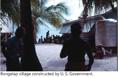
By December 1954, nine months after contamination, the radiation levels at Rongelap were still too high to allow the Marshallese to return. However, teams of scientists had visited the atoll three weeks after the contamination, and again three times in 1955, and from then until 1957, the Atomic Energy Commission had completely demolished all buildings on Rongelap and constructed a modern village. On June 29, 1967, all of the Rongelapese arrived back home on a U.S. Navy LST which had carried them and their belongings from Majuro, where they had been sent three years before.

Photo of Rongelap village, taken by the author, Capt. Leroy Reinburg, Jr.
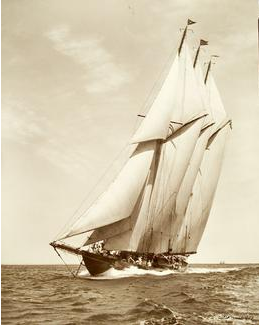
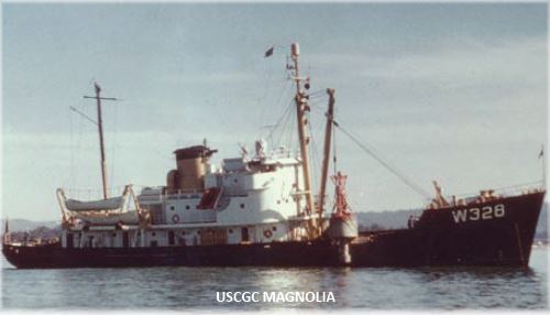
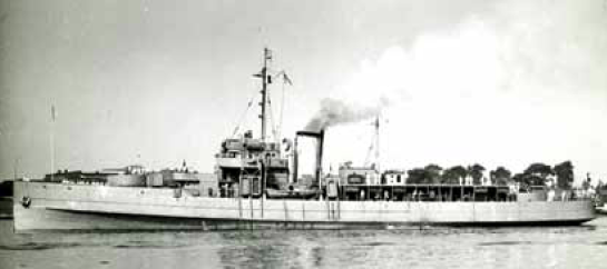
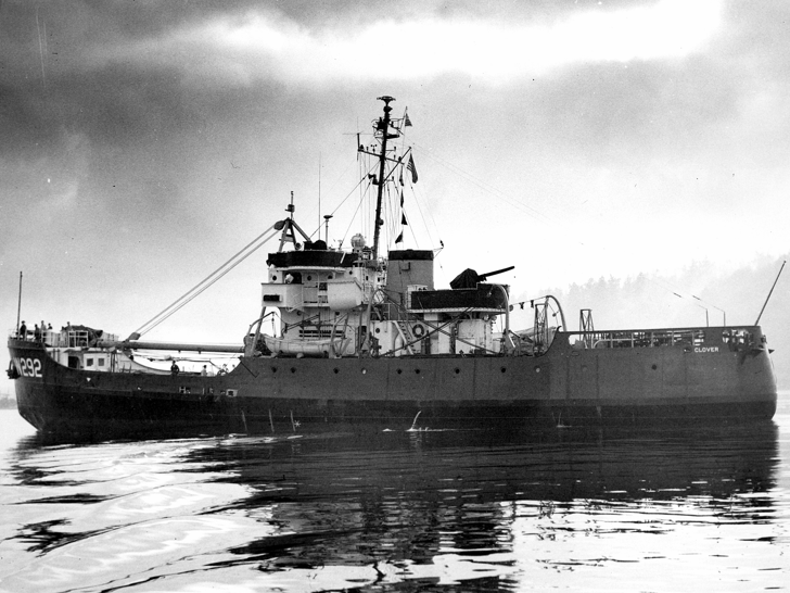
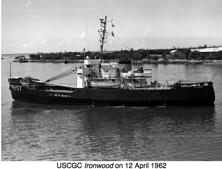
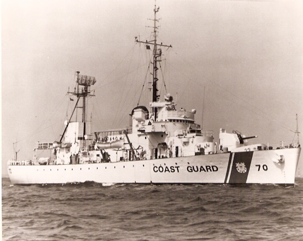
In the spring of 1963, the Commandant, U.S. Coast Guard, in response to an Atomic Energy Commission request, agreed to provide a ship to support a team of scientists performing bioenvironmental resurvey of Rongelap a decade after the detonation. The tragic consequences of shot “Bravo” at Bikini assumed a more personal aspect for me when the ship selected for this task was the USCGC IRONWOOD (WAGL-297), stationed in Honolulu, Hawaii, of which I was the Commanding Officer. A date of mid-August had been tentatively set for the survey, and the Commander, 14th Coast Guard District directed that the IRONWOOD would extend its regular aids to navigation trip to the Marshall Islands to provide the necessary support

U.S. Coast Guard Cutter Ironwood 1962Through correspondence with Dr. Edward E. Held, Research Professor of Radiation Biology, University of Washington (the chief scientist of the party), I learned that the expedition would commence at Eniwetok, where a temporary laboratory would be constructed on the IRONWOOD’s buoy deck. This laboratory would consist of living area for seventeen people, work benches, sinks, refrigerators, ovens, deepfreezes, and a pump and suction hoses for the collection of plankton samples.

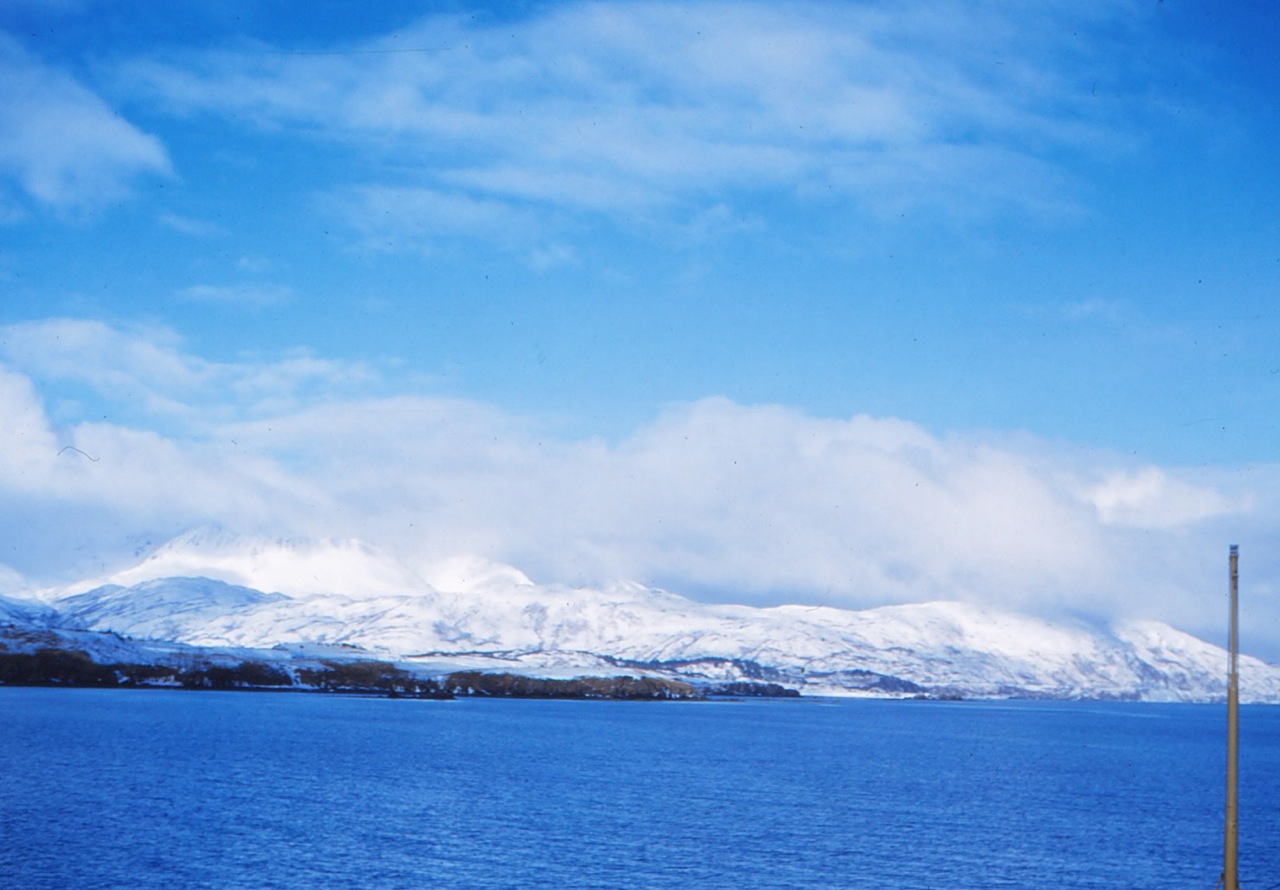
The IRONWOOD had been committed to twelve days at Rongelap, during which time, six of the major islands of the atoll would be visited, for varying periods from several hours to several days. Inspection of charts of Rongelap (U.S. Navy Oceanographic Charts 6029, 6030, and 6031) revealed that the western two thirds of the lagoon contained no data except for the location of the islands and the fringing reef. The eastern part of the lagoon, however, had been charted by the Japanese between 1917 and 1927, and showed very detailed, and as I discovered later, very accurate soundings, obstructions, and bottom composition; best of all, the whole area had been wire dragged to a depth in excess of fifteen fathoms. This was very reassuring; however, the IRONWOOD would be required to visit essentially the entire uncharted area of the lagoon, as well.

Anticipating that we might be required to feel our way around uncharted waters, I obtained two portable fathometers, which could be mounted on ship’s boats. My plan was to have a boat, or two boats, precede the ship into uncharted waters to give warning of an approaching obstruction. In June 1963, Lieutenant Commander B. L. Meaux, Commanding Officer, USCGC PLANETREE, visiting Kwajalein, and knowing of my desire for information on Rongelap, requested from the local U.S. Naval command, low-level color, aerial photographs of the lagoon. These photos were received on board upon our arrival in Kwajalein in August 1963. These photographs were excellent and gave a strong indication that the western part of the lagoon, although it had a few obstructions, was navigable.

When I first received word of our trip, I felt like Christopher Columbus embarking on his voyage of discovery, but as events unfolded, I had to admit that Columbus did not have aerial reconnaissance, radar, portable fathometers, and charts (such as they were) to remove some of the uncertainties that faced him. I believed that I had made pretty good use of the techniques available to me to reduce the risks of navigating the Rongelap lagoon, which consisted of large areas of white paper on the charts. Even the Japanese administrators of the League of Nations Mandate of the Marshall Islands had made their contribution to the success of our expedition.

On August 13, 1963, having finished all of our aids to navigation work in the Marshall Islands, we offloaded all of our buoys and appendages onto a barge at the Kwajalein Pacific Missile Range Facility to allow construction of the laboratory on the buoy deck. Due to much prefabrication and very competent work, the laboratory installation was completed the next day. After reprovisioning, we departed Kwajalein for Rongelap late on August 15.

Just after noon the next day, we entered South Pass, just to the west of Rongelap Island, the largest island in the atoll. We anchored in the wire dragged area about a mile from the village on Rongelap and established contact with the scientific party, which had flown in from Kwajalein. I went ashore to meet with Dr. Held and to meet the Trust Territory Representative and the Village Magistrate. The Magistrate told me that the villagers were eager to trade native crafts for soap, candy, cigarettes, etc., but in order not to upset the local economy, he advised bargaining. The Magistrate also asked that no one from the ship remain ashore after dark.

Killer clams on the beach
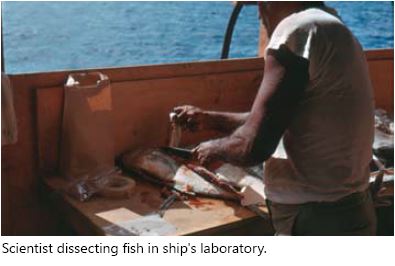
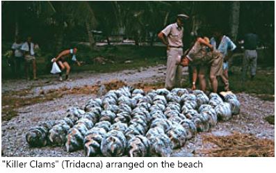
Liberty was granted until sunset and all hands enjoyed bartering for Tridacna (giant) clam shells, Marshallese stick charts, map cowries, other sea shells, straw fans, etc. The remainder of the day was spent (by me) meeting the rest of the scientific party, and watching them blast fish with Primacord, which we had brought from Kwajalein. The scientists cut open the stunned fish for their liver, ovaries, pancreas, and other internal organs. The flesh from the fish was given to the very appreciative villagers. The children ate the raw fish as it was handed out!

Scientist dissecting fish on deck of the shipThe scientists came out to the ship with many agricultural samples that required processing. We remained anchored overnight taking plankton samples. In the evening, at my request, Dr. Held gave a lecture to the entire crew to explain the purpose of the expedition. He explained that although there were many tragic effects of the nuclear test, it provided a scientific windfall, since there was no other known instance of single, heavy radioactive fallout on a diverse geographic area. It provided a marker to determine coral growth, examine the effect on plant growth, fish, crustaceans, and much, much more.

The next morning, the entire scientific party came on board, with all of their gear, including camping equipment. The credentials of the group were impressive. Their areas of expertise included: Invertebrate Zoology, Soils, Botany, Algology, and Geology.

The next ten days consisted of travelling into the entire lagoon, eighty percent of which was uncharted, and visiting all of the islands, taking many samples of fish, which were checked for radiation. Everywhere, Geiger Counter readings were taken and recorded. When we got underway, it was only when the sun was high in the sky to make coral reefs visible, and we were preceded by our boat equipped with a portable fathometer.

Track of USCGC Ironwood, Marshall Islands 1963, drawn by Capt. LeRoy Reinburg, Jr., when he was Commanding Officer of the USCGC IRONWOOD

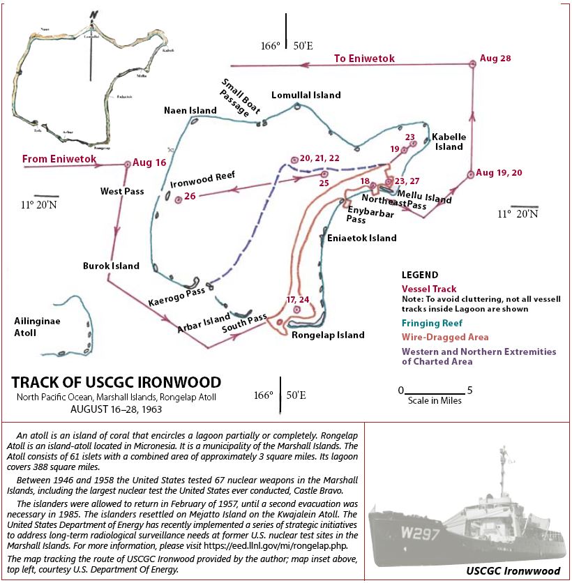
Track of U.S. Coast Guard Cutter IRONWOOD, Marshall Islands, Rongelap Atoll, August 16-28, 1963. Map drawn by Capt. LeRoy Reinburg, Jr., U.S. Coast Guard-Retired

In the course of our travels, we discovered nine uncharted islands, and one large reef that bared at low tide. Dr. Held and I decided to assign names to these geographic features. The reef, appropriately, was named “Ironwood Reef.” The Rongelapese word for small island is “bokan,” and so we named one Bokan Petrel for the smallest commissioned ship in the Coast Guard, other islands were named for Dr. Held’s wife, my wife “Bokan Marjorie,” and one of my daughters “Bokan Anora.” Because I had five children, this posed a problem in the selection, so I drew straws. All of these together with other hydrographic data we had collected were submitted to the U.S. Navy Oceanographic Office.

We departed Rongelap on August 28, 1963, for Kwajalein to have the temporary laboratory removed from our buoy deck and reclaim our aids to navigation cargo. The scientists were flown out of Rongelap by a U.S. Navy HU-16.

In the years following the March 1, 1954, nuclear accident, a high number of Marshallese have undergone surgery for cancer or potentially cancerous thyroid nodules. This has been particularly evident in those who were young children when the fallout occurred. It appears that the effects of radioactive fallout are not only slow in developing, but also a hazardous dose occurs at a much lower level of exposure than had been previously believed. Perhaps the tragedy of March 1, 1954, has further chapters to come.

(Originally published in Officer Review, Vol. 48 No. 10, June 2009, The Military Order of the World Wars.)

Editor’s Note: For updated information on the Marshall Islands in 2015, see Washington Post reporter Dan Zak’s November 27, 2015, article A Ground Zero Forgotten: The Marshall Islands, once a U.S. nuclear test site, face oblivion again.
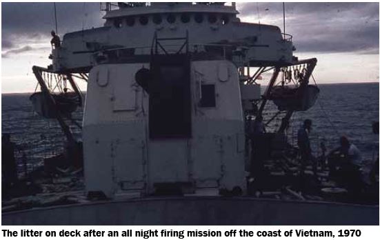
Share this:
Posted in USCGC IRONWOOD | Tagged , , , , , , , | Leave a comment

“Watch Where You Step, and Don’t Touch Anything,” by Captain LeRoy Reinburg, Jr., U.S. Coast Guard– Retired

Share this:

In September of 1949, I was an ensign attached to the Coast Guard Cutter CLOVER. Although our home port was Kodiak, Alaska, we spent only three weeks there in the fourteen months I was on her. Most of the time, we operated out of Adak, which at that time had a large U.S. Naval Base and a U.S. Air Force Base. This made sense, since most of our area of operations was well to the west of Kodiak: the Aleutian Islands and Northern Alaska. The Naval Base provided us wonderful logistic support, that is, POL (petroleum, oil, and lubricants), commissary supplies, spare parts, miscellaneous other supplies such as paints, and to some extent, recreation facilities. Summer in the Aleutians is very foggy, and the temperature seldom gets above the mid 50 degrees Fahrenheit range. Unlike the rest of the year, storms are relatively rare in that area during the summer.

Photo of U.S. Coast Guard Cutter Clover, 1953

U.S. Coast Guard Cutter Clover. (U.S. Coast Guard photo)

We were scheduled to make a trip westward from Adak, as far as Attu, the westernmost island of the Aleutians, servicing shore and floating aids to navigation, including the Attu USCG Loran A Station. It was customary on these trips to notify the CO of the Naval Base of our itinerary, which allowed him to send supplies, personnel, and light cargo to the small Naval Meteorology Base on Attu. Although Attu had an airstrip for the delivery of mail and other light cargo, surface transportation was needed for heavy and bulky cargo.

Prior to our trip, we had been advised by our operational commander, the Commander, 17th Coast Guard District in Juneau, that he had given permission to the Navy to send an explosive ordnance survey team with us to determine the extent of munitions left behind on various islands. The pullout of the major part of U.S. Forces from the Aleutians at the end of WWII in 1945 had been hasty, and no one knew what had been left behind. Some of the munitions were thought to be deteriorating due to the wet and humid conditions in the Aleutian Chain.

With the Navy team on board, we departed to stop at many of the islands west of Adak, some to work aids to navigation, in addition to those with abandoned military bases. According to The Alaska Coast Pilot, most of the larger islands in the Aleutians provide some sheltered anchorages, which are discussed at great length. The better known harbors are: Akutan Harbor on Akutan Island, Dutch Harbor on Unalaska Island, Nazan Bay on Atka Island, all east of Adak, Kuluk Bay on Adak Island, Constantine Harbor on Amchitka Island, and Massacre Bay on Attu. Nearly all beaches in the Aleutian Islands present natural obstacles to landing.

The Coast Pilot goes on to say that the shores are generally precipitous; the breakers are heavy and in many cases the approaches are filled with jagged rocks and kelp beds which are unusually abundant in the Aleutians. Sandy beaches are rare, usually being found only at the heads of bays, and in no case does a beach extend more that 50 yards inland from the high water mark. When heavy swells and seas are encountered along a beach, a landing in a small boat should not be attempted as there are strong and dangerous undertows accompanied by variable currents. In addition to the lack of surveys, navigation in this region is made difficult by the prevailing thick weather and further by the lack of knowledge of the currents which attain considerable velocity at times.

Even as young and inexperienced as I was, I recognized that working some of the shore lights would be hazardous. What the Coast Pilot didn’t mention was that many of the places we would be required to land had large populations of extremely aggressive sea lions, who were very jealous of their territory. Our tactic to deal with this hazard involved approaching close to the beach and firing flares from a Very’s Pistol into the congregation of sea lions, then landing quickly in the area cleared by the flares, walking through the herd and proceeding as rapidly as possible to the high ground behind it. If you have never been close to a snapping and snarling two-ton sea lion, it’s hard to describe the imminent danger.

Photo of stellar sea lions on shore in Alaska

Stellar sea lions, Alaska. (Photo from U.S Fish and Wildlife Service)

In those days, the Coast Guard used acetylene as fuel for both the lighted floating and shore aids. To make the operation more difficult, the acetylene was in compressed gas accumulators, called A-25’s, which weighed 125 lbs. and had to be wrestled through the herd of sea lions and up some pretty steep slopes. I have not mentioned that acetylene is highly explosive and must be handled with great care. Brass, non-sparking tools had to be used in making any contact with the acetylene. Since I was the youngest officer in the wardroom, in addition to being the aids to navigation officer, I was in charge of many working parties sent ashore to recharge the lights, check the flasher, make sure it was “on characteristic,” and inspect the exterior of the light, repainting it if necessary. On a number of occasions I slipped getting out of the boat and found myself up to my hips in ice cold water.

Our first stop involving only the ordnance survey was Amchitka Island. This had been a U.S. Army Air Force Fighter Base, with a very short runway. Planes taking off were required to speed down what looked to me like 20-degree slope and get airborne by the time the runway ended at the water’s edge. Conversely, when they landed, it was uphill, and the strip ended in the base of a mountain. My hat was off to these courageous pilots. The mostly abandoned base had a small U.S. Army security detachment.

There were a number of very large warehouses that contained the most unusual collection of munitions and weapons I have ever seen before or since. There were what seemed like endless rows of aerial bombs, cases of hand grenades, small arms ammunition, and what was the most surprising sight of all was a huge pile of small arms, both U.S. and Japanese. There were pistols, carbines, rifles, loose hand grenades, bazookas, plus bandoleers of ammunition of all kinds, even individual clips of cartridges, links of .50 caliber cartridges for aerial guns, plus much, much more. One of the most puzzling items, and there were many of them, were small brightly-colored devices, with small propellers. We were told not to touch these; this weapon had been launched by the Japanese attached to hydrogen filled balloons and went high enough to reach the jet stream, to be carried to the eastward. As they eventually descended, the propeller activated the explosive charge before they landed. Their object was to make them attractive as souvenirs to unsuspecting American civilians. It was a hit or miss weapon, which the Japanese released by the thousands, hoping that the winds would bring them to the “Lower 48.” I understand from later reading that a number of them did in fact land in Washington and Oregon. We were told in no uncertain terms not to touch them, however, the Security Detail told us we could take what we wanted from the small arms and ammunition. I got permission from the CO to take some M1 rifles, carbines, with accompanied ammunition. These weapons were to be stored in the ship’s armory and used for crew’s recreational use, subject to strict supervision.

We stopped, briefly at Kiska, which the Japanese had occupied. When the U.S. invasion force landed to remove them, they found that the Japanese soldiers had been evacuated at night by submarines. We were warned not to touch anything, since the Japanese had booby-trapped many of the desirable souvenirs. There did not appear to be much residual munitions on the island from either the Japanese or U.S. forces, so we did not spend too much time there. The harbor contained several sunken Japanese cargo ships and landing craft.

We did not stop at Shemya, the next island to the west, since this was used as an active refueling point by mostly trans-Pacific commercial traffic. Before it had been converted to civilian use, the island was searched thoroughly for any dangerous residue. We continued on to Attu, which had, wonders of wonders, a well-tended long pier which extended 500 to 600 feet out into Massacre Bay, the island’s only harbor. Here the Ordnance Team discovered a mother lode of abandoned ordnance, including drums of mustard gas. We stayed there for about a week. The weather was beautiful, most unusual for that time of the year, and groups of us took the opportunity to do a little exploring.

A map of Attu island, Alaska, dated 1953

Map of Attu Island, Alaska, 1953. (From www.loran-history.info/Attu/attu.htm)

We climbed the steep hills, which the U.S. Forces took in fierce fighting. The evidence of this was everywhere, including abandoned weapons and helmets, both U.S. and Japanese, and gruesomely, many human bones and skulls. Remembering our warning not to touch anything, we simply looked. One thing we saw were double rows of 2- to 3-foot white stakes driven into the ground. Other than to note these, and there were many, we just prowled the old battlefield. Later, back aboard the ship we told the Ordnance Team members about the puzzling white stakes. They reacted with undisguised horror when we told them that we had walked all around these stakes. They said, these were “corridors” cleared of land mines by the bayonets of American Soldiers at great risk, since the land mines were ceramic and could not be located by mine detectors. The decision was made after the combat operations were completed to simply leave the remainder of the mines in place, and wait for the rains and high humidity to gradually deactivate them. No one knew how many years this would take! And we had been wandering innocently all over the minefields! The lesson was a sobering one, don’t venture off the main roads. But most important of all, watch where you step, and don’t touch anything! The remainder of the trip was somewhat anticlimactic; our innocence could have made us casualties four years after the end of WWII. I will never forget this.

(Originally published in Officer Review, Vol. 45 No. 10, June 2006, The Military Order of the World Wars. Awarded the Vice Admiral George C. Dyer Award, First Place.)

Share this:
Posted in Alaska, U.S. Coast Guard in Alaska, USCGC CLOVER | Tagged , , , | Leave a comment

“The Yap Mooring Buoy,” by Captain LeRoy Reinburg, Jr., U.S. Coast Guard–Retired

Share this:

Yap is a small island in the Western Caroline Islands southwest of Guam, Mariana Islands. In 1963 Yap was administered by the United States as a part of the United Nations Trust Territories of the Pacific Islands. After World War I, Yap was a part of the League of Nations Mandate administered by Japan. However, after World War II, Japan’s control of Yap, together with the remaining islands of the Mandate, was terminated, and it was placed under the tutelage of the United Nations.

From the time that Japan’s Mandate started, it violated the terms of the Mandate by building military bases on all of the main islands, ostensibly for “national defense,” but it was obviously for a more sinister reason, as World War II demonstrated. As soon became obvious, it allowed them to extend their military control over a broad expanse of the southwest Pacific as WWII began. Yap, for example, became a major military air base. As these islands began to be retaken by the U.S. these strategic islands became available for the installation of electronic aids to navigation stations, which greatly expanded the scope and coverage of the U.S. main all weather navigation system, that is Loran-A. Loran-A was a secret medium frequency, hyperbolic system that provided positioning information to ships and aircraft equal in accuracy to celestial navigation, that is 1 to 2 miles, in its coverage area, despite overcast conditions. This was huge benefit in an area known for its frequent overcast conditions.

Loran-A was indispensable all during WWII; however, it had its limitations. For example, due to its limited range, it required an extensive number of stations to cover the wide expanses of the Pacific. A newer system became available in the late 1950s and 1960s, known as Loran-C, which had the advantage of longer range, lower frequency and higher power, and higher accuracy. This of course meant fewer stations covering a greater area with greatly improved accuracy. Yap Island became a prime location for one of these new stations.Blowing a hole in the reef of Yap Harbor

In 1963, I was the Commanding Officer of the Coast Guard buoy tender IRONWOOD (WAGL-297), stationed in Honolulu, Hawaii. My ship was tasked with putting a mooring buoy in Yap Harbor, a very small harbor, barely accessible to large ships. The purpose of this buoy was to accommodate the Coast Guard cargo ship the KUKUI, carrying construction material, whose length made it impossible for it to swing around a conventional anchor. The mooring buoy mooring was required to be placed in a hole blown in the harbor fringing reef, which was then to be filled by concrete, sealing in a 2,000-pound concrete sinker attached to a heavy chain which would lead up to the buoy. When the ship was moored to the buoy, it would drop a stern anchor, and between these two would keep the ship from swinging, and thus grounding on the reef. The IRONWOOD would accomplish this task during its regular five-month “round robin” Western Pacific (WESTPAC) aids-to-navigation voyage.

I understood in theory how this was to be done but could anticipate a number of problems. First and foremost among the anticipated problems was pouring concrete under salt water. No one in the District staff had ever poured concrete under salt water and had no idea how to advise me what to do. My last advice was to “improvise.” In other words, I was on my own. But they did have confidence in me that I would “find a way.” With these words of advice I was on my way. The Coast Guard prides itself on its ability to improvise.

Since Yap was at the far reaches of our voyage, we accomplished a significant portion of our aids-to-navigation work enroute. During our lengthy trip to Yap, I conferred with the officers and crewmembers who would be doing the work. Although none had had any experience with pouring concrete under salt water (or any other kind of water), they were experienced in construction work, which we had to do on shore aids to navigation and had a wealth of knowledge and experience in buoy work. The advantage of this conferring allowed them to be thinking about the problem, and any other associated problems, which paid off handsomely in the work, which eventually we accomplished.

One additional Yap task was to do a hydrographic survey of the harbor. I assigned responsibility to a newly assigned Academy grad ensign, who did a magnificent, innovative job, and for which the ship received a congratulatory message from the District Commander. I made sure a proper recognition was given to the ensign in his fitness report.

Since no mention was made by the District staff about how the hole was to be blown in the reef, an essential part of the whole operation, I made provision for a Navy explosive ordnance demolition team to meet us at Yap. We carried the explosives from Guam to Yap, and the explosive ordnance demolition (EOD) team flew in to Yap on a Coast Guard aircraft furnished by the Coast Guard air detachment stationed in Guam and were there on Yap when we arrived. This was very helpful since they “scoped out” the job before our arrival and were ready to provide us with their requirements. These included providing them with small boat for the divers to look at that portion of the reef that required the hole to be blasted to accommodate the mooring buoy sinker.

Now I turned to the remaining problem to be addressed, that is, pouring the concrete under water. While I pondered the problem, Sunday rolled around, and I found that wonder of wonders, there was a Catholic Church on the island. I attended Mass, and afterward, the priest noticed an unfamiliar face in the congregation and invited me into the rectory for a cup of coffee. He was an American member of the Society of Jesus (a Jesuit.) He had been on Yap for a number of years and told me some of the 400-year-old history of this missionary outpost. It was a fascinating story, and he had volumes of records going back to the 1500s to back up the history, all kept in Latin. He recounted how during the last ten years, he had constructed small chapels all over the island, and on Sundays, he made a circuit of all of them, saying Mass. I thought I had an opening, and told him of our problem, that is, pouring concrete under salt water.

He turned around in his chair and pulled a civil engineering book off the shelf, which was dedicated to the uses of concrete. He opened the book and showed me a chapter titled “Pouring Concrete Under Water.” I had found the solution to my problem! I asked him if I could borrow the book and promised to return it promptly. He agreed, and I returned to the ship, jubilant. I gathered my team of experts together, and we reviewed the book thoroughly. They now had their key, and as I expected, developed a plan. One was detailed to arrange for a large barge, to be borrowed from the Trust Territory Representative, who also arranged for provision of a small cement mixer. The Engineer Officer began planning to fabricate a metal trough to be placed from the mixer, over the side and long enough to reach the bottom of the hole that was to be blown in the reef. This would allow the wet cement to settle in the bottom of the hole, rather being dispersed as it hit the water. I left them alone to develop the remaining details of the plan, confident that the arrangements were in good hands.

The next day, we met again to firm up the plan, which was put into effect the following day with the blowing of the hole in the reef. When the divers inspected the hole after the water had cleared, they found it to be larger than they expected, however, we compensated for this by using more cement. The concrete sinker with its heavy-duty chain was hoisted into the hole with the ship’s buoy crane. We were now in business. The next day we started mixing and pouring concrete. As the textbook predicted, the wet cement flowed and settled nicely in the bottom of the hole. We allowed several days for the concrete to set.

Due to expert planning and execution, the remainder of the project went exactly as expected. The mooring buoy was in place due to excellent coordination and assistance from the Trust Territories Representative and the Catholic Church, but most credit had to go our wonderful crew of experts on the ship, who made it all happen. I was proud of everyone, and I made certain that this was reflected in our official report. I made certain that everyone involved received official recognition in his personal file.Inspecting the wreckage of a Japanese Zero fighter found on the beach in Yap.

(Originally published in Officer Review, Vol. 49 No. 9, April 2010, The Military Order of the World Wars)

Share this:
Posted in USCGC IRONWOOD | Tagged , , | 1 Comment

“R & R,” by Captain LeRoy Reinburg, Jr., U.S. Coast Guard–Retired

Share this:

During most of 1970, my ship, the Coast Guard Cutter PONTCHARTRAIN (WHEC-70), of which I was the Commanding Officer, was deployed to Vietnam as a part of the U.S. SEVENTH Fleet. We were assigned to Commander, Task Force ONE ONE FIVE, the Offshore Surveillance Force. Our mission, together with five other WHECs, Navy destroyers, destroyer escorts, and other Navy and RVN assets, was to interdict North Vietnamese trawlers, who were constantly trying to penetrate our barrier patrol and land supplies and personnel to support the Viet Cong (VC) in the Republic of Vietnam (RVN). In addition, we would provide naval gunfire support (NGFS) to friendly forces ashore.

The total deployment was about ten months, and during this time we would be on combat patrol for roughly four to six weeks, with an in-port maintenance period at the U.S. Navy Base, Subic Bay, Republic of the Philippines. This schedule also provided brief, occasional rest and recreation (R&R) visits to other foreign ports, such as, Hong Kong, Singapore, Kao-Hsiung, and Bangkok. The combat patrols varied in operational intensity from relatively routine to sometimes frantic.

One of our duties required NGFS to the U.S. Navy Riverine Force Base at Song Ong Doc in the U Minh Forest area of South Vietnam. This latter duty would involve anchoring several hundred yards off the river entrance and responding to “call for fire” from the navy base, which was ringed by precisely charted magnetic, seismic, and acoustic sensors. The VC were constantly attempting to overrun the base, mainly at night. When the base received a sensor activation, they would give us a call for fire, and we would fire rounds at the sensor location. This required going to general quarters (GQ) Condition THREE, shore bombardment (SHOBA) on very short notice. Personnel would be roused in the middle of the night with the sound of the GQ pinging and would have to race to their battle stations, half asleep, and be prepared to respond to a “battery released” command. Sometimes this would occur four and five times a night, making many sleepless nights.

In addition to this, VC swimmer sappers were constantly trying to attach limpet mines to the hull of the ship, which if exploded would open a large hole in the hull. For this reason, whenever we were anchored close to shore, there were armed sentries roaming the weather decks, armed with rifles and concussion grenades. They were instructed to fire on any objects in the water, and at random intervals toss grenades in the water to discourage swimmers sappers. Since we were anchored off the river entrance, there was much flotsam streaming out of the river, particularly coconuts, which resembled a swimmer’s head.

Photo of litter on the deck of USCGC Pontchartrain after an all-night firing mission in 1970

In sum, between GQ, the rattle of gunfire, and the detonation of grenades, sound sleep was almost impossible when we were at anchor. One of the crew likened it to sleeping inside a bass drum. Being underway wasn’t much of an improvement for me, since I was called frequently to report sightings, engineering casualties, release messages, changes in maneuvering, and other occurrences in a seemingly endless array. I never complained about being called any time the officer of the deck (OOD) was in doubt. To do so might discourage him from calling me for something very important.

With this rather lengthy discourse, I wanted to “set the stage” for the main point of my article. After four or five months of this “routine,” when we arrived in Subic Bay for maintenance, I found myself very stressed out and jumpy. I had difficulty sitting still for any length of time, and even more difficulty in concentrating. I spoke to the executive officer, a wonderful, experienced, self-possessed “mustang.” This term is used to describe officers who came up through the enlisted grades. Or as, my father, an old Coast Guard hand used to say, they “came up through the hawse pipe instead of over the gangway.” I told him I had to get off the ship for a few days, and I intended to ask the Coast Guard Squadron Commander to grant me some leave while we were in port. He assured me that he could handle things during my absence. The Squadron Commander, an old time friend agreed, but said, he would give me “leave in a basket,” that is, I would file leave papers with him, and if I came back in “one piece,” he would tear them up.

Photo of Vic, the guide and driver the author met while on R&R in the Philippines, 1970.The next day, I hired a car and driver through the Navy Exchange, at the exorbitant rate of 6 US dollars per day! The exchange rate at that time was 8 pesos to the dollar, and the peso had the same purchasing power in the local economy as a dollar did in ours, so the exchange and the driver were well compensated. I packed a bag and left the next morning on what would be one of the most interesting and satisfying trips I have ever taken. My driver’s name was “Vic.” He spoke beautiful English, as is common in the Philippines, and I told him I wanted to go to Baguio, which is a mountain resort north of Manila, on the main island of Luzon. I would stay at Camp Hay, a U.S. Army Recreational Facility. I told Vic that I would like to take an interesting route and he assured me he knew of several.

I had heard of the Bataan Death March, during the early days of World War II, and asked Vic if this was on the way to Baguio. He was somewhat hesitant, but agreed. I found out later why. We picked up the Death March route well above Marivales, where it started on April 10, 1942, after 76,000 U.S Army and Philippine Scouts surrendered to the invading Japanese Army. As we drove the route, Vic displayed a very comprehensive knowledge of the event, explaining in detail what had transpired. After WWII, the Philippine government had erected memorials along the route commemorating those who died. At one stop, as he spoke, Vic was visibly emotional. He told me in a halting voice that he was a survivor of the Death March, having escaped along the 60-mile route to Camp O’Donnell, where they were to be incarcerated. After his escape, he joined the Philippine guerillas and fought the Japanese in the jungles until the end of the war. He told of the utter brutality of the Japanese guards, who bayoneted and shot, and in some cases beheaded Americans and Filipinos who dropped by the side of the road from exhaustion on the 5 to 6 day journey, due to heat, malnutrition, and lack of water. Of the original 76,000, only 54,000 reached the prison camp!

Photos of two sites memorializing the Bataan Death March in the Philippines during WWII.

As Vic spoke, I, too, was overcome with thoughts of the terrible ordeal and forgot about my troubles which seemed petty compared with what Vic and his fellow prisoners endured. It somehow had a cathartic effect on me, and as the trip wore on, I noticed that I was a little more calm and collected.

The remainder of the trip went by rapidly. Vic spent the nights with his family, and during the day, he chauffeured me around the lovely city of Baguio. The nights were positively chilly, after the oppressive heat of Subic Bay. We even had a fireplace in the hotel and a fire in the evening provided a comforting sight. After several days relaxing in Baguio, our trip back to Subic was uneventful and oddly had a deeply calming effect on me. On our arrival in Subic, I gave Vic a substantial tip, and I could hear the catch in his voice as he accepted it. I think I had helped him as much as he helped me, and I had made a new friend. I returned to the ship feeling refreshed and ready to get “back in battery,” as the gunnery people say.

(Originally published in Officer Review, Vol. 49 No. 6, January/February 2010, The Military Order of the World Wars)

Share this:
Posted in U.S. Coast Guard in Vietnam, USCGC PONTCHARTRAIN, Vietnam War | Tagged , , , , | Leave a comment