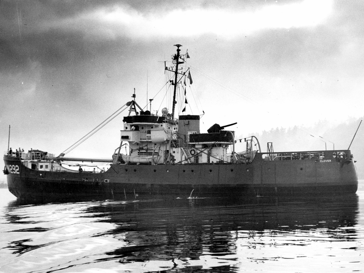
In September of 1949, I was an ensign attached to the Coast Guard Cutter CLOVER. Although our home port was Kodiak, Alaska, we spent only three weeks there in the fourteen months I was on her. Most of the time, we operated out of Adak, which at that time had a large U.S. Naval Base and a U.S. Air Force Base. This made sense, since most of our area of operations was well to the west of Kodiak: the Aleutian Islands and Northern Alaska. The Naval Base provided us wonderful logistic support, that is, POL (petroleum, oil, and lubricants), commissary supplies, spare parts, miscellaneous other supplies such as paints, and to some extent, recreation facilities. Summer in the Aleutians is very foggy, and the temperature seldom gets above the mid 50 degrees Fahrenheit range. Unlike the rest of the year, storms are relatively rare in that area during the summer.
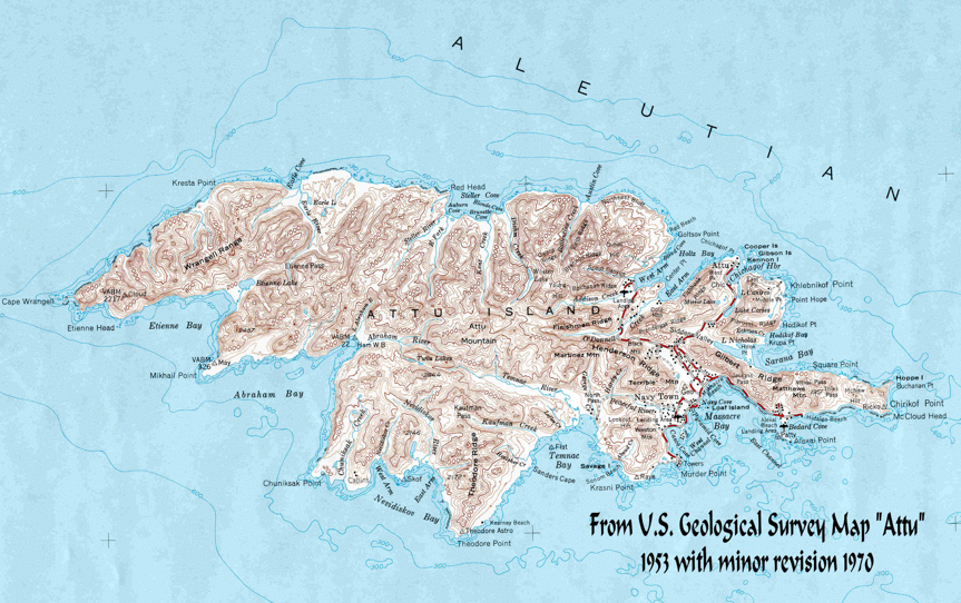
We were scheduled to make a trip westward from Adak, as far as Attu, the westernmost island of the Aleutians, servicing shore and floating aids to navigation, including the Attu USCG Loran A Station. It was customary on these trips to notify the CO of the Naval Base of our itinerary, which allowed him to send supplies, personnel, and light cargo to the small Naval Meteorology Base on Attu. Although Attu had an airstrip for the delivery of mail and other light cargo, surface transportation was needed for heavy and bulky cargo.
Prior to our trip, we had been advised by our operational commander, the Commander, 17th Coast Guard District in Juneau, that he had given permission to the Navy to send an explosive ordnance survey team with us to determine the extent of munitions left behind on various islands. The pullout of the major part of U.S. Forces from the Aleutians at the end of WWII in 1945 had been hasty, and no one knew what had been left behind. Some of the munitions were thought to be deteriorating due to the wet and humid conditions in the Aleutian Chain.
With the Navy team on board, we departed to stop at many of the islands west of Adak, some to work aids to navigation, in addition to those with abandoned military bases. According to The Alaska Coast Pilot, most of the larger islands in the Aleutians provide some sheltered anchorages, which are discussed at great length. The better known harbors are: Akutan Harbor on Akutan Island, Dutch Harbor on Unalaska Island, Nazan Bay on Atka Island, all east of Adak, Kuluk Bay on Adak Island, Constantine Harbor on Amchitka Island, and Massacre Bay on Attu. Nearly all beaches in the Aleutian Islands present natural obstacles to landing.
The Coast Pilot goes on to say that the shores are generally precipitous; the breakers are heavy and in many cases the approaches are filled with jagged rocks and kelp beds which are unusually abundant in the Aleutians. Sandy beaches are rare, usually being found only at the heads of bays, and in no case does a beach extend more that 50 yards inland from the high water mark. When heavy swells and seas are encountered along a beach, a landing in a small boat should not be attempted as there are strong and dangerous undertows accompanied by variable currents. In addition to the lack of surveys, navigation in this region is made difficult by the prevailing thick weather and further by the lack of knowledge of the currents which attain considerable velocity at times.
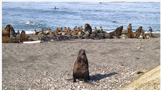
Even as young and inexperienced as I was, I recognized that working some of the shore lights would be hazardous. What the Coast Pilot didn’t mention was that many of the places we would be required to land had large populations of extremely aggressive sea lions, who were very jealous of their territory. Our tactic to deal with this hazard involved approaching close to the beach and firing flares from a Very’s Pistol into the congregation of sea lions, then landing quickly in the area cleared by the flares, walking through the herd and proceeding as rapidly as possible to the high ground behind it. If you have never been close to a snapping and snarling two-ton sea lion, it’s hard to describe the imminent danger.
In those days, the Coast Guard used acetylene as fuel for both the lighted floating and shore aids. To make the operation more difficult, the acetylene was in compressed gas accumulators, called A-25’s, which weighed 125 lbs. and had to be wrestled through the herd of sea lions and up some pretty steep slopes. I have not mentioned that acetylene is highly explosive and must be handled with great care. Brass, non-sparking tools had to be used in making any contact with the acetylene. Since I was the youngest officer in the wardroom, in addition to being the aids to navigation officer, I was in charge of many working parties sent ashore to recharge the lights, check the flasher, make sure it was “on characteristic,” and inspect the exterior of the light, repainting it if necessary. On a number of occasions I slipped getting out of the boat and found myself up to my hips in ice cold water.
Our first stop involving only the ordnance survey was Amchitka Island. This had been a U.S. Army Air Force Fighter Base, with a very short runway. Planes taking off were required to speed down what looked to me like 20-degree slope and get airborne by the time the runway ended at the water’s edge. Conversely, when they landed, it was uphill, and the strip ended in the base of a mountain. My hat was off to these courageous pilots. The mostly abandoned base had a small U.S. Army security detachment.
There were a number of very large warehouses that contained the most unusual collection of munitions and weapons I have ever seen before or since. There were what seemed like endless rows of aerial bombs, cases of hand grenades, small arms ammunition, and what was the most surprising sight of all was a huge pile of small arms, both U.S. and Japanese. There were pistols, carbines, rifles, loose hand grenades, bazookas, plus bandoleers of ammunition of all kinds, even individual clips of cartridges, links of .50 caliber cartridges for aerial guns, plus much, much more. One of the most puzzling items, and there were many of them, were small brightly-colored devices, with small propellers. We were told not to touch these; this weapon had been launched by the Japanese attached to hydrogen filled balloons and went high enough to reach the jet stream, to be carried to the eastward. As they eventually descended, the propeller activated the explosive charge before they landed. Their object was to make them attractive as souvenirs to unsuspecting American civilians. It was a hit or miss weapon, which the Japanese released by the thousands, hoping that the winds would bring them to the “Lower 48.” I understand from later reading that a number of them did in fact land in Washington and Oregon. We were told in no uncertain terms not to touch them, however, the Security Detail told us we could take what we wanted from the small arms and ammunition. I got permission from the CO to take some M1 rifles, carbines, with accompanied ammunition. These weapons were to be stored in the ship’s armory and used for crew’s recreational use, subject to strict supervision.
We stopped, briefly at Kiska, which the Japanese had occupied. When the U.S. invasion force landed to remove them, they found that the Japanese soldiers had been evacuated at night by submarines. We were warned not to touch anything, since the Japanese had booby-trapped many of the desirable souvenirs. There did not appear to be much residual munitions on the island from either the Japanese or U.S. forces, so we did not spend too much time there. The harbor contained several sunken Japanese cargo ships and landing craft.
We did not stop at Shemya, the next island to the west, since this was used as an active refueling point by mostly trans-Pacific commercial traffic. Before it had been converted to civilian use, the island was searched thoroughly for any dangerous residue. We continued on to Attu, which had, wonders of wonders, a well-tended long pier which extended 500 to 600 feet out into Massacre Bay, the island’s only harbor. Here the Ordnance Team discovered a mother lode of abandoned ordnance, including drums of mustard gas. We stayed there for about a week. The weather was beautiful, most unusual for that time of the year, and groups of us took the opportunity to do a little exploring.
We climbed the steep hills, which the U.S. Forces took in fierce fighting. The evidence of this was everywhere, including abandoned weapons and helmets, both U.S. and Japanese, and gruesomely, many human bones and skulls. Remembering our warning not to touch anything, we simply looked. One thing we saw were double rows of 2- to 3-foot white stakes driven into the ground. Other than to note these, and there were many, we just prowled the old battlefield. Later, back aboard the ship we told the Ordnance Team members about the puzzling white stakes. They reacted with undisguised horror when we told them that we had walked all around these stakes. They said, these were “corridors” cleared of land mines by the bayonets of American Soldiers at great risk, since the land mines were ceramic and could not be located by mine detectors. The decision was made after the combat operations were completed to simply leave the remainder of the mines in place, and wait for the rains and high humidity to gradually deactivate them. No one knew how many years this would take! And we had been wandering innocently all over the minefields! The lesson was a sobering one, don’t venture off the main roads. But most important of all, watch where you step, and don’t touch anything! The remainder of the trip was somewhat anticlimactic; our innocence could have made us casualties four years after the end of WWII. I will never forget this.
(Originally published in Officer Review, Vol. 45 No. 10, June 2006, The Military Order of the World Wars. Awarded the Vice Admiral George C. Dyer Award, First Place.)


